
Arizona Neighbors Around One Block
For Arizona neighbors, “nearby” may mean a touching parcel, a home on the same street, or an organization whose boundary crosses an address. Arizona has no one public list for all three. A county parcel map shows land; an assessor record links an APN, or assessor parcel number, to owner and address fields; a city directory shows community boundaries and public contacts. These Arizona sources answer separate questions. An owner's mail address does not name everyone living on nearby parcels.
| Source | What It Shows About a Block | Access |
|---|---|---|
| Arizona county GIS parcel layer | Touching parcels, APNs, geometry, streets, and sometimes owner/address links | Public map or map service; verify each result. |
| Arizona county assessor parcel card | Recorded owner, physical address, mailing address, valuation, and legal class | County portal, counter, phone, or record request. |
| Arizona county recorder plat or CC&R | Lot, block, subdivision, easement, and association clues | Recorder index, map search, or counter. |
| Arizona voter registration record | Some public registration fields, with privacy and use limits | County recorder request or inspection for an authorized purpose. |
| Arizona city neighborhood directory | Organization boundary, name, type, or public contact flags | City address or geographic search; no member roster assumed. |
| Arizona directories and census | Dated past households and neighborhood context | Library, Archives, or Arizona Memory Project collections. |
An Arizona county assessor record can show who owns a parcel and where tax notices go; neither proves who is there today. An Arizona GIS layer shows map relationships, not a household list. Arizona voter and historical records follow their own dates and rules. Compare dated records before treating a name as a match.
Arizona Neighbors via Phoenix Link
Phoenix Neighborhood Link is an inspected Arizona city directory. Its address search requires Street Number, Direction, Street Name, and Type, then names organizations whose boundaries intersect the property. It does not list members or everyone living there. This Phoenix, Arizona tool also browses by council district, alphabetical list, geographic area, intersection, police precinct, organization ID, and citywide organizations.
Use the Phoenix Neighborhood Link address search to check which community organization covers an address; the image shows the required address fields and result view.
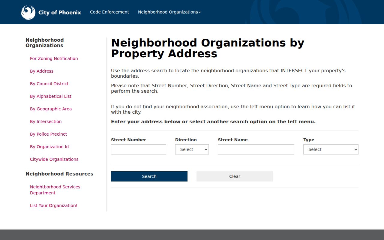
A matching result means the Phoenix address intersects an organization's boundary. Arizona users should treat the name and contact flags as a route to the group, not as a private roster. Phoenix's Arizona layer lists organization name, ID, type, and flags for website, alternate or daytime phone, email, and address.
Arizona Neighbor Parcels and APNs
For an Arizona block map, start with the target parcel, not a broad radius. The Maricopa Arizona parcel service supports spatial and distance queries and returns geometry, coordinates, APN, owner, mailing address, and physical address. A nearby shape is only a candidate; a street, alley, wash, or rail line may put it outside the intended block.
- Find the Arizona address in its county assessor or parcel viewer and record the APN.
- Use Arizona parcel edges or a small distance query to find nearby APNs, then check which lots touch.
- Open each Arizona APN separately and save owner, physical address, mailing address, and map relation.
- Carry the Arizona APN or legal description to the recorder for a deed, plat, or subdivision record.
Arizona's Maricopa map selects nearby parcels, but each needs an individual record check. Save the Arizona viewer date, base map, layer, target APN, radius, and any road or drainage feature between lots. A recorded plat or Arizona county mapping office can resolve a boundary conflict. For a whole street's chain, use the Arizona street directory rather than treating every block parcel as one address search.
Record whether the Arizona result means same ZIP, same subdivision, same street, or touching parcel. These rules yield different neighbor groups, and a distance query alone does not verify adjoining properties.
Arizona Resident Fields in Maricopa
Maricopa County's assessor and GIS tools give the clearest inspected Arizona owner-to-parcel path. The layer distinguishes a site's physical address from its mailing address and links both to an APN. It also exposes deed number and date, sale date and price, coordinates, area, and geometry. These Arizona fields point to records for verification; they are not a resident roster.
| Maricopa Field | What It Shows | How It Helps |
|---|---|---|
| APN / APN_DASH | Arizona parcel number, with dashed or undashed form | Stable key for assessor, map, and recorder searches. |
| OWNER_NAME | Name tied to the Arizona parcel record | Search the county owner field with a full recorded name. |
| PHYSICAL_ADDRESS and PHYSICAL_ZIP | Arizona property location and postal ZIP fields | Keep the site's place distinct from its mail destination. |
| MAIL_ADDR and MAIL_ZIP | Owner correspondence address and ZIP for an Arizona parcel | May point off parcel or out of county; not a residence claim. |
| DEED_NUMBER, DEED_DATE, SALE_DATE, SALE_PRICE | Recorded instrument and transaction clues | Bridge to recorder history and help date a parcel event. |
Maricopa's Arizona assessor search help accepts an APN with or without dashes, a full owner name, or a street address. Address parts include number, direction, street name, type, city, state, and ZIP, though city, state, and ZIP may be omitted. If an Arizona search misses, remove street type. Results can show more than one parcel; open the APN record before deciding.
Arizona Voter Records Have Limits
The Arizona voter information portal is a self-check for an individual voter, not a public street roster. It asks for a county and last name with a birth date or another identity method; some Arizona address functions route Maricopa and Pima users to county tools. The result checks one voter's status, not every Arizona household on a block.
Arizona law permits inspection of nonconfidential voter information at the county recorder for purposes authorized by A.R.S. §16-168. Public fields can include name, party preference, registration date, residence and mailing address, ZIP, birth year, precinct, and recent voting history. An Arizona public result does not promise every field to every requester. The county recorder handles a voter-file request; state the permitted purpose and avoid protected details.
Arizona safeguards withhold month and day of birth, Social Security and driver's-license numbers, tribal identification, parents' names, birth state or country, signatures, and email. A.R.S. §16-153 can protect eligible Arizona officials, public-safety workers, and people at the same address. The Address Confidentiality Program uses a substitute address for qualifying participants. Arizona voter data cannot be posted or shared outside uses allowed by law.
Arizona Community Directories and Contacts
Arizona neighbors can use a community directory to find a group and its public contact, not its members. Phoenix is the inspected address-search example; nearby Arizona city services in Mesa, Tucson, Tempe, Scottsdale, Glendale, Flagstaff, and Yuma are separate systems. In rural Arizona, use county GIS, recorded plats, or a public civic page.
| Community Route | Arizona Information It Can Offer | Access and Limit |
|---|---|---|
| Phoenix Neighborhood Link | Boundary, organization name and type, and public website or contact flags | Address, district, area, intersection, precinct, ID, or citywide browse; not a member roster. |
| Other Arizona municipal neighborhood services | Local organization or historic-district directory where offered | Use the Arizona city that contains the parcel; availability varies by city. |
| Arizona recorded plat and CC&R documents | Subdivision, lot/block, easement, association, or developer clues | Search the Arizona county recorder by subdivision or business name. |
| Civic, church, school, and veteran groups | Public meeting, event, or contact details | Use a group's public page; do not assume a private member list. |
Arizona State Library and local collections add dated context through newspapers, yearbooks, and community histories. An Arizona calendar or school notice may show that a group met at a place, not who lives there now. Keep the source date and contact the organization through its public channel when a boundary is unclear.
Arizona Parcel Records: Plats and CC&Rs
An Arizona plat lays out lots, blocks, roads, and easements. Covenants may name a subdivision or group, giving an Arizona search another path when an address misses the organization map. Maricopa's recorder supports business-name and document-code searches; try the subdivision name as well as an owner. It records submitted instruments but does not decide their legal correctness.
Maricopa reports a large historic index, but its current full-text instructions describe a two-year retrieval window. Pima's Arizona indexing is incomplete; watermarked images are online, while older searches can use public terminals at 240 N. Stone Ave. and 6920 E. Broadway Blvd. in Tucson during business hours. The Arizona county recorder directory points to each county's separate portal and copy route.
If an Arizona plat or CC&R is missing online, ask the county recorder for the map, lot and block, instrument, or older index by name and date. Arizona Public Records Law allows inspection or copy requests; copying and postage may cost extra. Name the record and custodian.
Arizona Neighbor Directory or Data Tool
An official Arizona parcel workflow is slower than a commercial neighbor tool, but each result can be traced to a map layer, APN, assessor card, recorder instrument, or dated directory. A commercial category tool may combine property, address, marketing, and directory data, then attach names to one Arizona address. Treat them as leads to check, not as a county record or proof of who lives there.
- Official Arizona county and city records
- Show fields each custodian keeps, such as a parcel boundary, recorded owner, deed, plat, or public group contact. The source and date can be checked.
- Commercial neighbor lookup
- May gather several data feeds into a single view. Treat Arizona names and nearby-address matches as unverified leads, and return to the source office before relying on them.
For an Arizona block result, state the boundary rule, keep each APN separate, and note the source date. A map shows touching parcels, not visitors or private member lists.
Privacy Around Arizona Neighbors
Public property records can identify a recorded owner and mailing destination; utility and delivery account data are not public household lists. An Arizona code case may name an applicant, contractor, complainant, or responsible party, not every person at the parcel. Directory entries and voter records also reflect a date and rule. The Arizona Address Confidentiality Program lets qualifying survivors use a substitute address with agencies.
Arizona's privacy rules apply even when a record is easy to reach. Arizona neighbors can use public material for lawful personal, family, property, or civic research. Do not use a block lookup to watch, threaten, or harass anyone. Do not infer a protected address from nearby records.
Respect privacy. Arizona records support lawful research about parcels and public organizations. Do not use an address or name to stalk, intimidate, or harm a person.
When an Arizona boundary or owner name remains uncertain, ask the county mapping or recorder office about the plat, legal description, or source field. A careful result names a map relation and record, not an unsupported household claim.